 | Debating Glacial Theory, 1842 – Background | ||||
| Home || Project Profile || Roles || 1830s Context || GoogleEarth Tour || Episodes | |||||
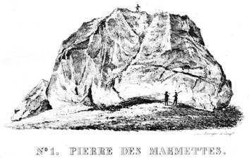
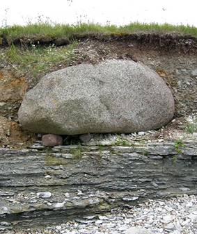
This case study examines how naturalists understood landscapes in northern Europe in the early 1800s and how this understanding was challenged in 1840 with the new idea of continental glaciation. Numerous observations and problems became relevant to the debate. You can experience some of this yourself through the GoogleEarth Tour. This allows you to visit several locations studied by naturalists in the early 19th Century, allowing you to understand and consider their work in this visual context. At this time geology emphasized local field observation and inductive inference over the global theorizing that had characterized the early history of the discipline. Indeed, many criticized the new concept of glaciation as based on too little observation and containing too much theorizing. One landscape feature that had long puzzled people all across northern Europe was the phenomenon of “erratics” (Fr. erratiques – “wanderers” Ger. findlingen – “foundlings”). The most spectacular erratics are massive, isolated boulders that geologists quickly recognized were not derived from the local bedrock: therefore, evidently they had been transported to their present location from a source often many miles distant and often across valleys or seas. The question was: how did they move to their present location?
The massive Pierre des Marmettes erratic, Monthey, Switzerland. Other features that geologists believed came from the time of the erratics included striated (scratched) and grooved bedrock, and roches moutonnees (“sheep rocks”) – rounded bedrock knobs that were smooth, often striated, on one side and ragged on the other: in any given area, it was always the same sides that were striated or ragged.
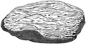
Striated rock (~1/8 scale), Wesserling, Thur valley, Vosges region of France
There was also the puzzle of the loose sands and gravels and unsorted clays (“boulder clay” or “till”) that covered much of the bedrock over northern Europe, and which contained erratics of all sizes, down to the size of the smallest pebble. This “diluvium” or “drift,” as it was termed, was clearly not river alluvium (it was found on divides as well as in valleys and often formed ridges – moraines – that were quite distinct from levees): but what was its origin? “Boulders” and “clay” was an unusual mix of materials – all known agents of transportation and deposition tend to sort (or winnow) material by size.
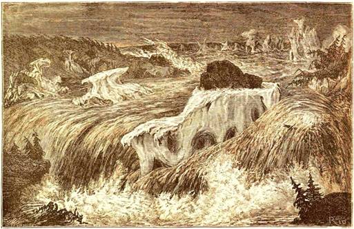
Whatever the answer(s) to these puzzles, they had to cohere with other ideas geologists held about Earth. For example, the origin of valleys was actively debated in the 1700s and much of the 1800s: some believed that valleys were the result of river erosion acting over a long period of time; others – the majority during much of the first half of the century – reasoned that larger valleys and those valleys that cut across regional rock structure, in particular, were formed by a major flood or some such catastrophe in the recent past. This flood had perhaps also laid down the layer of loose sediment found over much of the solid bedrock. Those who accepted a flood mechanism possibly also had a mechanism to transport erratics, if it could be shown that water could move such large objects. Terrestrial and marine rocks were commonly seen to alternate with each other, and geologists in the early 1800s felt justified in believing that the layers in the bedrock contained evidence of many such watery catastrophes (“debacles”) through time: so the idea of a final deluge prior to the establishment of the “present order of things” was not alien to their thinking: that this deluge might be the Genesis Flood was, for a time, a happy possibility.
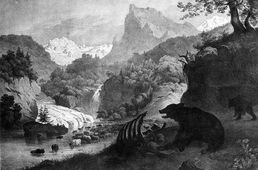
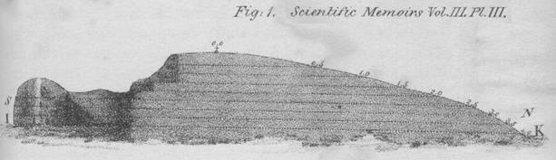
If a series of regional floods or deluges was responsible for diluvial (drift) deposits and landforms, then the question arose as to the cause of the flooding. Here, the question of these deposits and landforms perhaps connected with ideas concerning mountain-building. The majority opinion, including that of the philosopher William Whewell, was that mountain building was a rapid process of an intensity that was unknown today: the primary evidence of this lay in the extensive, high-altitude "convulsed strata" that were well documented in numerous studies of The Alps and other mountain ranges. Possibly uplift was sufficiently rapid as to generate huge inundating waves along with melting of mountain glaciers: the latter could generate a flotilla of ice-bergs that might carry off huge boulders into distant parts.
"Upheaved strata forming mountains . . Alps. St.
Gothard to the right." Other geologists, such as Charles Lyell, did not doubt that land and sea had interchanged frequently, though less dramatically. He was disposed to see a greater uniformity in the workings of the planet -- or, at least, worked hard to interpret the rock record in these terms: hence the subtitle of Lyell’s “Principles of Geology” -- “Being an attempt to explain the former changes of the Earth's surface, by reference to causes now in operation.” To someone like Lyell, a strict uniformitarian, the idea of full-blown, lowland, continental glaciation was suspiciously “catastrophic” -- certainly out of the ordinary as he saw the workings of the planet.
Roderick Murchison, a colleague of Lyell, was a strong proponent of the action of water on the land. To him, the "glacier theory" as extended beyond the Alps was "beyond the bounds of legitimate induction" and constituted a "doctrine" that might, he feared, "take too strong a hold on the mind." However, in 1842, he could point to the fact that "the greater number of practical geologists of Europe are opposed to the wide extension of a terrestrial glacial theory" and "the greatest geological authorities on the continent, led on by Von Buch who has so long studied these phaenomena in his native land, are opponents to the views." Therefore, by 1840 geologists had several theories that made sense of surface features they all recognized -- no one disputed what an erratic was, or that striations and roches moutonnees generally lined up in the same direction within the same region, or that boulder clay was an unusually unsorted material, etc. – but how all these were understood to have been formed was subject to debate. And when glaciation was suggested, even on a limited regional scale in the Alps, neither catastrophist nor uniformitarian found it easy to accommodate it within their frame of thinking. The rock record that was best known at the time (the Tertiary) was limited and, while it undisputedly contained abundant evidence of the action of water across the European landmass, there was nothing to suggest the direct action of glacial ice (although the seas that covered the land at various times might bring in ice bergs). In fact, if anything, fossil evidence suggested that climate had been warmer (not glacial) in the geologic past. If a glacial theory was to be accepted, then existing ideas about processes, climate, and the nature of environmental change would have to be revised, rejected or "looked upon . . . with new eyes." OR OR OR
REFERENCES Agassiz, L. 1837
Discours prononce a l’ouverture des seances Société Helvétique des Sciences
Naturelles, a Neuchatel le 24 Juillet 1837. Actes de la Société
Helvétique des Sciences Naturelles, réunie ŕ Neuchâtel, p. v-xxxii
http://books.google.com/books?id=e_taAAAAQAAJ&pg=PR5 [Opening
remarks by the President of the Society: “The discourse of Neuchatel”] Berger, W.H. 2007 On the discovery of the ice age: science and myth. pp. 271-278 in L. Piccardi and W.B. Masse (eds.) Myth and geology Geological Society of London, Special Publication 273 GSL, London http://www.google.com/books?id=F7pZfLUoHJIC Buckland, W. 1820 Vindicić geologicć; or The connexion of geology with religion explained, in an inaugural lecture delivered before University of Oxford, May 15, 1819, on the endowment of readership in geology (William Buckland Publisher, Oxford) http://www.uwmc.uwc.edu/geography/Buckland/Vindiciae Geologicae William Buckland.pdf Charpentier, J. de 1841 Essai sur les glaciers et sur le terrain erratique du bassin du Rhone (Marc Ducloux, Laussane) http://books.google.com/books?id=eGwsSDuzkSAC&pg=PP7 Collomb, E. 1847 Preuves de l'existence d'anciens glaciers dans les vallées des Vosges (Victor Masson, Paris) http://books.google.com/books?id=8usTAAAAQAAJ http://jubil.upmc.fr/sdx/pl/doc-tdm.xsp?id=GR_000363_001_d0e35&fmt=upmc&base=fa&root=&n=&qid=&ss=&as=&ai= Cuvier, G. , Brongniart, A. 1811 Essai sur la Géographie Minéralogique des Environs de Paris http://books.google.com/books?id=HQQTAAAAMAAJ&pg=PP7 de la Beche, H.T. 1830 Sections and views illustrative of geological phenomena. (Treuttel & Wurtz, London)http://books.google.com/books?id=6DQAAAAAQAAJ&pg=PT16#v Figuier, L. 1863 The world before the deluge (Cassel, Petter, Galpin & Co., London) http://imgbase-scd-ulp.u-strasbg.fr/displayimage.php?album=963&pos=3 http://www.geology.19thcenturyscience.org/books/1872-Figuier-BeforeFlood/htm/doc.html Hitchcock, E., 1841a Final report on the geology of Massachusetts: Vol. I. containing I. Economical geology. II. Scenographical geology. (J.H. Butler, Northamption MA) http://books.google.com/books?id=sTcAAAAAQAAJ&pg=PR1#v Hitchcock, E., 1841b First anniversary address before the Association of American Geologists at their Second Annual Meeting, Philadelphia, April 5, 1841. (B.L. Hamlen, New Haven). http://www.google.com/books?id=ErkQAAAAIAAJ&pg=PA1#v Lyell, C. 1833 Principles of geology, volume 2 (John Murray, London) http://www.google.com/books?id=JoW8AAAAIAAJ&pg=PR1#v Lugg, A. 1978 Overdetermined problems in science. Studies in the History and Philosophy of Science v.9(1) p.1-18 Murchison, R.I. 1842 President's Anniversary Address 1842: The glacial theory. Proceedings of The Geological Society of London v.III (Nov. 1838- Jun. 1842) part II (1842) no.86 p.671-687 http://www.google.com/books?id=giPPAAAAMAAJ&pg=PA671 Rudwick, M.J.S. 2009 Biblical flood and geological deluge: the amicable dissociation of geology and genesis. p.103-110 in M. Kolbl-Ebert (ed.) Geology and religion: A history of harmony and hostility. Geological Society, London, Special Publication 310 (Geological Society, London) http://books.google.com/books?id=w1NUHmio_jEC&lpg=PP1&pg=PP1#v Sefstrom, N.G.
1836 [pub.1838] Undersökning af de räfflor, hvaraf Skandinaviens berg äro med
bestämd riktning fĺrade, samt om deras sannolika uppkomst. Kongliga Vetenskaps
Academiens handlingar, for the year 1836 p.141-227 [An investigation of the
furrows which traverse the Scandinavian Mountains in certain directions,
together with the probable cause of their origin.]
http://books.google.com/books?id=Q7g4AAAAMAAJ&pg=RA1-PA41 Unger, F. 1851 Ideal Views of the Primitive World, in its Geological and Palaeontological Phases (Taylor and Francis, London) Whewell, W. 1831 Review of volume 1 of Lyell's "Principles of geology." The British Critic, Quarterly Review, and Ecclesiastical Record v.9, p.180-206 http://www.archive.org/details/britishcriticqua09londuoft
|
|||||