 | Debating Glacial Theory, 1800-1870 – Epilog, Part 3 |
| Home || Debate Profile || Epilog, Pt.1 || Epilog, Pt.2 | |
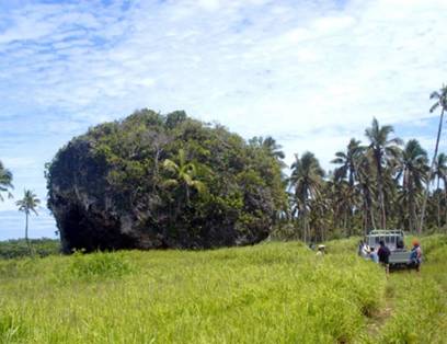
This case study has focused on the history of glacial geology and glaciology in the 19th century, yet a good deal further work was completed in 20th Century, particularly in regards to causes of glaciations throughout geologic time (e.g. Milankovitch) and chemical evidence of glaciation from sea-floor sediments (e.g. Emiliani) and ice cores (e.g. GRIP). In particular, there are some interesting updates on specific issues that were being discussed in the first half of the 19th century. “ERRATICS,” TIDAL WAVES, AND FLOODS 1. Tsunami erratics: While not on the scale envisaged by Hall (1812), large tidal waves have recently been found capable of moving blocks of considerable size at least a short distance.
Tsunami-transported coral boulder, Tonga, 400 meters
inland.
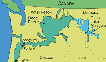
2. Glacial dam burst and flood: A catastrophic failure of a glacial dam on the Idaho-Montana border in the late Pleistocene released up to 500 cubic miles of water and shaped the landscape of thousands of square miles of Idaho, Washington and Oregon states. This includes canyon erosion, giant ripples and potholes, streamlined hills, and erratics ice-rafted over 400 miles in some cases. "The high water mark for the floods in the Pasco Basin (1200 ft elev.) is based on the maximum observed height of erratics, which is coincident with channeling at Wallula Gap. . . . The erratics [in Badger Coulee] apparently became grounded against the steep hillside, 200 ft above the valley below, as Lake Lewis drained. The larger erratic is 42 ft around at the base, 11 ft high and estimated to weigh 100 tons. Applying Archimedes Principle, the size of the iceberg carrying these erratics must have been at least 25 times greater than the erratics themselves. . . . The high water mark for the floods in the Pasco Basin (1200 ft elev.) is based on the maximum observed height of erratics" (Bjornstad, B. 2008, p.29-31). Giant ripple marks are also very much in evidence in this region. Initially, the interpretation of this topography in this manner by j. Harland Bretz in the 1920s was rejected as “catastrophist” – the story is briefly told by Gould (1978) and there is an exercise by Magruder (1998).
http://geology.isu.edu/Digital_Geology_Idaho/Module13/LakeMissoula.gif
A streamlined loess hill, Palouse region, state of Washington. http://iceagefloods.blogspot.com/2009/02/ice-age-floods-rapids-canyons-and-bars.html
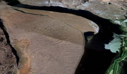
Giant ripples, West Bar (opposite Crescent Bar), Columbia River (GoogleEarth snapshot) A smaller example is the glacial flood that eroded the “Wisconsin Dells” as glacial Lake Wisconsin drained in south-central Wisconsin. 3. Flood geology makes a comeback: A resurgence of "flood geology" as part of the rise of Creationism must be noted. In fact, it is ironic that the only copy of Hall's 1812 work on giant tsunamis available on the internet is located on a creationist web site! Water gaps are also still being puzzled over by Creationists: "However, the Flood paradigm successfully explains these water gaps, as well as practically all others, and even wind gaps. Both wind and water gaps could have been rapidly carved during the Channelized Flow Phase of the Flood, when strong water currents were flowing perpendicular to mountains or ridges. An analog for a water and wind gap occurred during the gigantic Lake Missoula flood at the peak of the Ice Age" http://www.creationresearch.org/crsq/articles/44/44_3/Water_Gaps.htm.
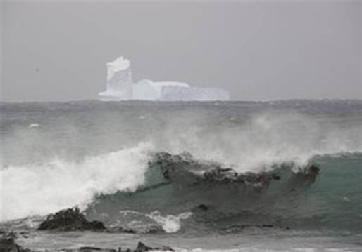
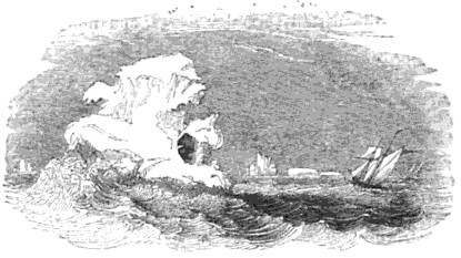
ICEBERGS IN MID-LATITUDES Compare this monster with the icebergs depicted in the "Introduction" and in the "Uniformitarian Drift" Episode, as described by Darwin. In November 2009 several large ice bergs showed up near New Zealand as part of the the Antarctic Ice-shelf broke up. "Large numbers of icebergs last floated close to New Zealand in 2006, when some were visible from the coastline - the first such sighting since 1931. The current flotilla of icebergs that split off Antarctic ice shelves is slowly drifting in the direction of New Zealand. The nearest one, measuring about 330 to 660 feet (100 to 200 meters) long, was 160 miles (260 kilometers) southeast of New Zealand's Stewart Island."
"In this Nov. 16, 2009 photo released by the Australian Antarctic Division, an iceberg is seen at Sandy Bay on Macquarie Island's east coast, in the Southern Ocean 1,500 kilometers (930 miles) southeast of Tasmania, Australia. It is very rare to see icebergs from Macquarie Island and is uncommon to find icebergs in this general region" (http://www.kansas.com/news/world/story/1070435.html?story_link=email_msg)
"Rock seen on ice-berg in 61° South Latitude"
REFERENCES Bjornstad, B. 2008 Aftermath of the ice-age floods: a birds’-eye view http://agg.pnl.gov/projects/birdseye.pdf Bressan, D. 2008 Erratic boulders. Cryology and Co. BLOG. http://rockglacier.blogspot.com/2008/09/erratic-boulders.html DeGrey, L., Link P.K. 2008 Lake Missoula Floods. Digital Atlas of Idaho http://geology.isu.edu/Digital_Geology_Idaho/Module13/mod13.htm Gould, S.J. 1978 The Great Scablands Debate, Natural History, August/September 1978, p.12-18 Hall, J, 1812 "On the Revolutions of the Earth's Surface, being an account of the diluvian facts in the neighbourhood of Edinburgh" Part 1 Transactions of the Royal Society of Edinburgh, v. 5, 1812. p. 139-167; Part 2 1812, v. 7, p.169-211 http://vinyl2.sentex.ca/~tcc/GT/Hall.html Hornbach, M., Frohlich, C., Taylor, F.W. 2008 Unraveling the source of large erratic boulders on Tonga: implications for geohazards and mega-tsunamis 2008 Joint Meeting of The Geological Society of America, Soil Science Society of America, American Society of Agronomy, Crop Science Society of America, Gulf Coast Association of Geological Societies with the Gulf Coast Section of SEPM Paper No. 149-8 http://gsa.confex.com/gsa/2008AM/finalprogram/abstract_149849.htm Magruder, K.,
1998, Great scablands, Montana Natural History Center 2008 Glacial Lake Missoula and the Ice Age Floods. http://www.glaciallakemissoula.org/ Schumaker, D. 2008 Boulders in Tonga evidence of largest tsunami debris ever found. The geology news BLOG. http://geology.rockbandit.net/2008/09/24/boulders-in-tonga-evidence-of-largest-tsunami-debris-found/ USGS 2008 Glacial Lake Missoula and the Missoula Floods. http://vulcan.wr.usgs.gov/Glossary/Glaciers/IceSheets/description_lake_missoula.html |
|
![[Streamlined-Palouse-Hills.jpg]](TwentiethCenturyUpdates_files/image005.jpg)