EPISODE:
UPPSALA TRACES, 1824-1828
"Blocs erratiques . . . a major geological problem . . . which more and well-directed observations will help answer, . . . should not be confused with speculative hypotheses ungrounded in solid theory."
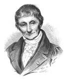
Alexandre Brongniart (1770 – 1847) was a colleague of Georges Cuvier. Like Cuvier, almost all of his research was on bedrock mapping and stratigraphy. However, while doing research on ancient rocks in the 1820s, he mapped trains of large, isolated boulders scattered across the landscape of southern Sweden. He used the term "erratic blocks" to designate these: "nous les désignerons sous le nom de blocs erratiques." He noted that they are not related to the local bedrock beneath them and are often separated from their place of origin by “immense plains” or across “substantial valleys.” He noted that they decrease in size toward the south in Sweden, yet “we cannot attribute this sorting to the same cause that produces it in rivers," because rivers leave behind the large stones and carry off the finer sand: but the erratics are commonly embedded within sand.
He remarked that this was the region where the erratics on the Baltic shore of northern Europe originated (not from southern Germany as some others had hitherto supposed). Noting their presence also in Denmark, he wondered how they could have crossed the “narrow but deep” Sound that separates Sweden from Denmark -- but, characteristically, he let his observation stand and refused to speculate on how it could have happened. He reviewed just how common erratics are in a variety of settings all across northern Europe and in the vicinity of the Alps. He described erratic blocks as a “major geological problem.”
De Saussure had described polished rocks and rounded hills in the Jura and Alps in print in 1786 and coined the term "roches mountonnees" to describe their characteristic resemblance to wigs that were then fashionable or to grazing sheep, but he believed they were caused by weathering of bedrock. Brongniart was the first to describe them outside this region and to note their consistent orientation: “a curious circumstance . . . the north-facing sides are the only which are polished, those that face south on the contrary are angular and rough.”
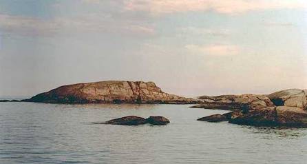
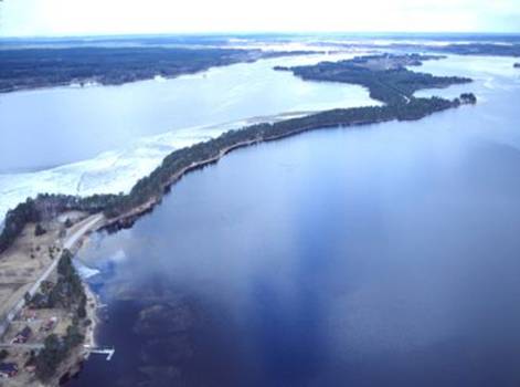
Roche moutonnee, Bullerö Nature Reserve,
Stockholm Archipelago
(http://www.progeo.se/news/97_4f/nordic.html)
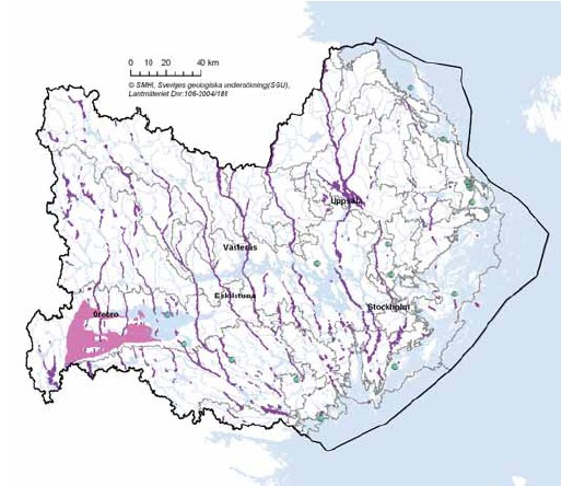
He mapped long sandy ridges (åse) in the Uppsala region. He noted that Swedish geologists had not yet noticed these features. These ridges, and also scratches in the underlying bedrock, were all orientated in a southerly direction.
These sandy ridges in the Uppsala region are tens of miles long. On the GoogleEarth view you see part of the Uppsala ridge system (a few miles north of Uppsala) – i.e. the discontinuous, treed ridge to the west (left) of the river. This Uppsalaåsen (Uppsala Ridge) is over 115 miles long (it is the far right of Brongniart’s map, below).
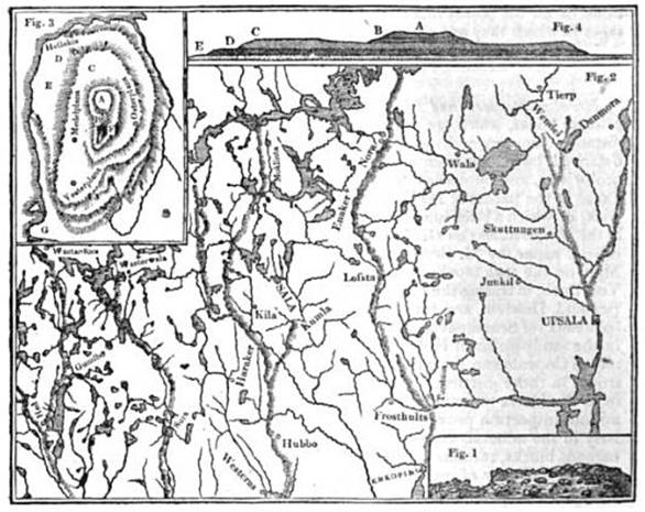
Brongniart's map
showing "the direction of long, narrow sand hills covered with erratic blocks N.
& W of Uppsala"
(The Magazine of Natural History 1829, p.486).
Hedesundaåsen (Hedesunda esker –
sand and gravel ridge), Gästrikland, north of Stockholm
http://www.gsi.ie/Education/European+Landscapes/Sweden.htm
He concluded his review of all these features with an uncompromising statement concerning the role of solid observation in science (p.21):
"Misters Buckland and Sedgwick: one cannot attribute this phenomenon [erratics] to any action nor any known force of water; one cannot explain it by any of the causes which govern the geological phenomena of our time. I have sought to add some observations to those we have that can lead to understanding of this great geological phenomenon of erratic blocks – to contribute, one day, to knowing the force which transported these blocks, in which direction it acted, at which geologic time it took place, and if it acted from only one location while acting in only one direction or if it started from several points with many centers of action. These are all questions which more and well-directed observations will help answer, and which should not be confused with speculative hypotheses ungrounded in solid theory."
Ten years later, Nils Gabriel Sefstrom (1787-1845), a well-known chemist who re-discovered Vanadium, extended Brongniart's work in southern Sweden through extensive mapping of striations and erratic trains. Sefstrom was less circumspect than Brongniart about causes: as he interpreted it, his map showed the flood waters fanning out across southern Sweden and heading out across what is today the Baltic (See "Petridelaunian Flood").
QUESTIONS:
REFERENCES:
Brongniart, A. 1828 Notice sure les blocs de roches des terrain de transport en Suede Annales des sciences naturelles XIV mai 1828 p.5-22 http://books.google.com/books?id=6BAuHGwrk0sC&pg=PA5
SUMMARY: Notice sure les blocs de roches des terrain de transport en Suede (Annales des sciences naturelles XIV mai 1828 p.5-22); per M. Alex. Brongniart; lue a la Societe philomatique le 12 Avril 1828 Bulletin des sciences naturelles et de geologie v.17 July 1829 p.151-156 http://books.google.com/books?id=yLcXAAAAYAAJ&pg=RA4-PA151
NOTICE IN ENGLISH: The Magazine of Natural History 1829 Natural history of foreign countries: Denmark The Magazine of Natural history v.1, p.485-487 http://books.google.com/books?id=GAEXAAAAYAAJ&pg=PA485
Carozzi, A.V. 1996 New historical data on H.-B. de Saussure's introduction of the terms Moraine (1764), Roches Moutonnees, and Serac (1788) to geology. Journal of Geoscience Education v.44, p.169-174
Sefstrom, N.G. 1836 [pub.1838] Undersökning af de räfflor, hvaraf Skandinaviens berg äro med bestämd riktning fårade, samt om deras sannolika uppkomst. Kongliga Vetenskaps Academiens handlingar, for the year 1836 p.141-227 [An investigation of the furrows which traverse the Scandinavian Mountains in certain directions, together with the probable cause of their origin.] http://books.google.com/books?id=Q7g4AAAAMAAJ&pg=RA1-PA41
SUMMARY: 1836 Ueber die spuren einer sehr grossen urwlelticher Fluth. Annalen der Physik und Chemie v.38 p.614-618 http://books.google.com/books?id=u1QrAAAAcAAJ&pg=PA614
FULL ENGLISH TRANSLATION: Sefstrom (Nils Gabriel). An investigation of the furrows which traverse the Scandinavian mountains in certain directions, together with the probable cause of their origin. S. H. Thomas (trans.) p.81-144, 382 (map) in R. Taylor (ed.) 1843 Scientific memoirs v.3 part 9 (R & J. E.Taylor, London) http://books.google.com/books?id=qsY-AAAAYAAJ&pg=PA82#v
ENGLISH SUMMARY: Anon, 1837 On the traces of a vast ancient flood (from Poggendorff's Annalen, 1836) The Edinburgh New Philosophical Journal v.XXIII (April-Oct, 1837) p.69-73
http://books.google.com/books?id=DhgXAAAAYAAJ&pg=PA69#v
RECENT HYDROGEOLOGY MAP OF THE RIDGE SYSTEMS: