EPISODE:
NEUCHATEL, SWITZERLAND,
1819
<<-- Episodes Listing
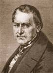 The
Prussian naturalist Leopold Von Buch (1774-1853) was a highly regarded
geologist and geographer. His travel writings were translated into several
languages and he contributed greatly to understanding igneous rocks as a class
of rock that derived from molten parent material.
The
Prussian naturalist Leopold Von Buch (1774-1853) was a highly regarded
geologist and geographer. His travel writings were translated into several
languages and he contributed greatly to understanding igneous rocks as a class
of rock that derived from molten parent material.
In 1810 von Buch
pondered the origins of the erratics on the Jura Mountains and in northern
Europe in general. Several erratics were of such a size as to seemingly defy
explanation by any process evident in the world: the Pierre-a-Bot erratic near
Neuchatel was (and still is) a huge granite block that had evidently come from
the Alps near Mont Blanc north across several intervening valleys to lie up on
the south-facing limestone slopes of the Jura. Von Buch and other naturalists
traced many other erratics from the Alps north along the Rhone valley to the
Jura (see
http://www.panoramio.com/user/426492/tags/Pierre for some images).
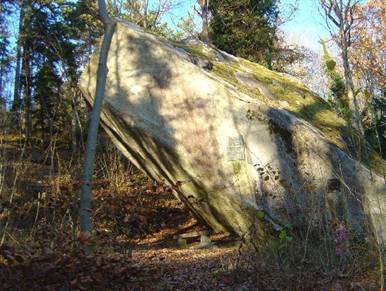
Pierre-a-Bot (Pierre Crapaud –Toad
Rock), outside Neuchatel, Switzerland
(for scale, note the bench seat).
(http://www.balades-en-famille.ch/show_pictures.php?photo=1110)
At first, in a lecture given in 1811 (published 1815), von Buch was reluctant to
ascribe the movement of the erratics to any one cause (de Luc's “explosions” or
Saussure's flood): however,
in 1818 a huge
landslide occurred in the Vals de Bagnes in the Swiss Alps, travelling several
miles into the upper Rhone valley. This was triggered by the bursting of an ice
dam and was just two valleys over from where von Buch knew the Pierre-a-Bot had
originated.
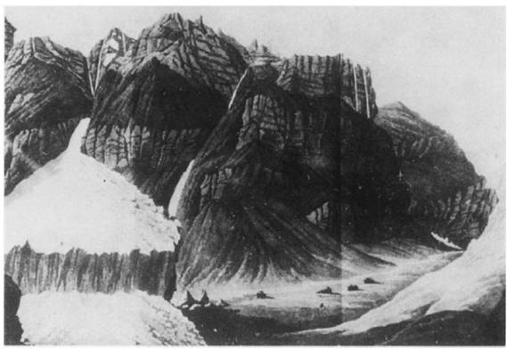
An 1818 sketch (Bridel,
1818): The Gietroz Glacier on the east side of Val des Bagnes at Mauvoisin has
advanced and is beginning to dam up the Drance River with ice fall into the main
valley.
The event was
described by Hans Conrad Escher:
". . . in half an hour the lake
was completely emptied, and the five hundred and thirty millions of cubic feet
of water which it contained, thundering down into the valley with a rapidity and
violence of which no idea can be formed . . . Enormous heaps of pebbles and
rocks, which the floods had carried off higher up, were deposited in the plains
. . . runs through the town of Martigny . . . covers the whole plain with thick
mud . . . According to the unanimous testimony-of the inhabitants, the flood
took up half an hour in passing every point which it reached; thus, in the short
space of thirty minutes, the whole mass of the water of the lake, drawing with
it all the debris, and forming a column of more than 530 millions of
cubic feet, passed every part of the valley. The flood then furnished in every
second 300,000 cubic feet of water . . . the flood took up thirty-five minutes
in coming from the glacier to Chable. The distance between these two points,
following the bed of the Dranse, is about 70,000 feet. The water, then
encumbered with all the rubbish, moved with the velocity of thirty-three feet in
a second. The velocity of the most rapid rivers is from six to ten feet per
second; very few attain to the velocity of thirteen ; thus, in the rectilineal
and perfectly regular canal of Mollis, the Linth, after this canal is full,
flows with a velocity of twelve feet per second. That of the torrent of the Val
de Bagne, multiplied by the half solid mass which was in motion, explains
extremely well the force with which forests, houses, and rocks, have been swept
off and carried to a distance. In passing from Chable to Martigny, the flood
must have occupied about fifty-five minutes. The distance between those two
places, following the windings of the valley, may be about 60,000 feet; the
medium velocity of the current then, in this extent, was about eighteen feet per
second. The inclination of that part of the valley being less than the upper
portion of it, and the water having lost a part of the impulse resulting from
its fall by the open gorge in the glacier, we may suppose that the velocity of
the current was considerably diminished in this valley, which was lower and of a
more uniform breadth; the time which the flood took up in passing through it,
therefore, was in all probability longer than that occupied in traversing the
upper valley."
Von Buch calculated that this kind of event could have been responsible for the
erratic (Seibold and Seibold, 2003). He suggested that a violent flood or
mudflow had washed out of the Alps, down the Rhone valley and washed the
erratics up on the lower slopes of the Jura with some of them being stranded on
the valley sides along the way (such consistent, unidirectional trains being
unlikely in the case of de Luc’s explosions, he argued). A mudflow would be more
capable of floating the boulders than water.
QUESTIONS:
- How is de Luc's original
"explosion" hypothesis affected by showing where these boulders originated?
- How might von Buch have
calculated that this kind of event could have been responsible for the
erratic movement?
- Might properties of the
deposits be useful to deciding on an origin?
- Erratics are found trailing
down the Rhone valley in this region: how might such a distribution affect
your judgment of de Luc's
"explosion" hypothesis versus von Buch's
"mega-mudflow" hypothesis?
- How universally-applicable is
von Buch’s hypothesis? For example, could it explain the erratics on the
North European Plain, as described by Wrede?
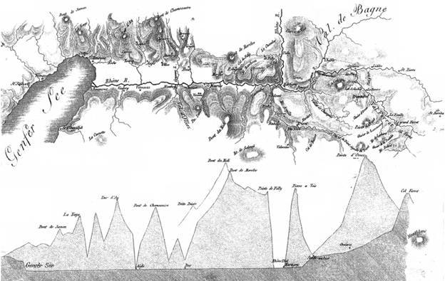
North is to
the left. “Genfer See” is Lake Geneva (Lac Leman). "Val de Bagne" is indicated.
The Pierre-a-Bot originated at the Pointe d’Ornex (the highest peak here, second
from the right on the cross-section) and travelled down the Val Ferret into the Val de Bagnes and
hence the Rhone valley (i.e. along the darker grey surface of the lower
cross-section). The south-facing slopes of the Jura Mountains are represented by
the bump up to the left of the Genfer See on the cross-section. Von Buch thus
ensured that the erratics had travelled to a lower altitude.
(von Buch 1819)
REFERENCES
A.C.
1921 Sur l'origine du nom de La Pierre des Marmettes. Annales Valaisannes,
February 1921
http://doc.rero.ch/lm.php?url=1000,43,19,1/I-N177-1921-005.pdf
Bridel, P-S
1818 Course a l'eboulement du glacier de Getros et au lac de Mauvoisin, au fond
de la Vallee de Bagnes, 16 Mai 1818
(Vevey, Loertscher)
"de" Buch, L., 1819 Additions au memoire sur les causes du transport des blocs
des transport des Alpes sur le Jura. Annales de Chimie et de Physique t.10
p.241-264 [A detailed review of the ideas of von Buch and de Luc by M.
Brochant-de-Villiers.]
http://books.google.com/books?id=zJc5AAAAcAAJ&pg=PA241
Davenport, R.A. 1840 The
inundation of the Vals des Bagnes p.377-389 in Narratives of peril and suffering
vol.II (London, Thomas Tegg)
http://books.google.com/books?id=n-K646egUQcC&pg=PA377#v
Deluc, J.A.
(the nephew) 1819 Lettre de J. André Deluc neveu aux Rédacteurs des Annales de
Chimie et de Physique, sur les Blocs de roches primitives épars dans certaines
vallées de la chaîne du Jura.
Annales de Chimie et de
Physique t.10 p.149-153
http://books.google.com/books?id=xzIFAAAAQAAJ&pg=RA5-PA149
Escher, H.C. 1818 Notice sur Ie Val De Bagnes en Bas Vallais, et sur la
catastrophe qui en a dévasté le fond, en Juin 1818.
Biblioteque
Universelle v.8 p.291-308
http://books.google.com/books?id=h7EUAAAAQAAJ&pg=PA291
TRANSLATION: A description of the Val de Bagne, in the Bas Valais, and of the
disaster which befel it in June 1818. Blackwood's Edinburgh Magazine (1819) v.IV
October1818-March 1819 p.87-95
http://books.google.com/books?id=k7_kaJqXduMC&pg=PA87
Grove J. M. 1987 Glacier Fluctuations and
Hazards. The Geographical Journal, v. 153(3), pp. 351-367
Seibold, E,
Seibold, I., 2003 Erratische Blöcke—erratische Folgerungen: ein unbekannter
Brief von Leopold von Buch von 1818 International Journal of Earth Sciences
v.92(3) p.426-439
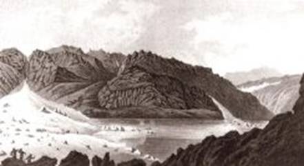
Lac de Mauvoisin, 1818
– the lake dammed by an ice fall of the Gietroz Glacier caused the disaster
http://www.glaciers-climat.com/naissance-de-la-glaciologie.html
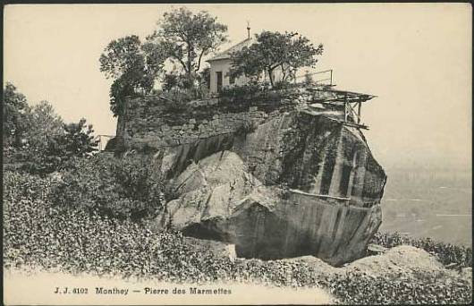
In 1905,
around the time of this photograph, this block was purchased by the town of
Monthey and the Swiss Society of Natural Sciences to protect it from quarrying
that had destroyed many erratics in the area.
(http://www.stefan-werthmueller.ch/Wallis%20work/Illiez-Panneau-VIII.pdf)
<<-- Episodes Listing