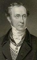
 Charles
Lyell (1797-1875) was the pre-eminent British geologist of his generation:
his text, “The principles of geology,” went to 12 editions between 1830 and
1875. Lyell made major contributions across much of the field of geology in his
time.
Charles
Lyell (1797-1875) was the pre-eminent British geologist of his generation:
his text, “The principles of geology,” went to 12 editions between 1830 and
1875. Lyell made major contributions across much of the field of geology in his
time.EPISODE:
UNIFORMITARIAN CONCEPTION OF “DRIFT" 1836-1839
Lyell and Murchison
“By growth as imperceptible as that of the forest tree” (Lyell, 1836).
“The agency of icebergs is not to be denied . . . But I would venture to caution geologists against enlisting them to account for too many effects” (Vetch, 1841).
Charles
Lyell (1797-1875) was the pre-eminent British geologist of his generation:
his text, “The principles of geology,” went to 12 editions between 1830 and
1875. Lyell made major contributions across much of the field of geology in his
time.
Lyell of was President of The Geological Society of London from 1835-1837 and from 1849-1851. In 1832 Lyell toured Europe on his honeymoon and met Charpentier who was impressed at the ideas of glacial extension in the Alps expressed by Ignaz Venetz and was in the midst of exploring these ideas for himself. In his Presidential address of 1836 Lyell briefly reviewed Jean de Charpentier’s ideas on Alpine glaciation (largely without comment) but offered some suggestions of is own regarding erratics in northern Europe. Lyell then followed this up with further study of the Norfolk coast between Happisburgh to Weybourne in 1839, which was published in 1840.
Lyell reported on observations of sea ice breaking off from coasts in the Denmark-Sweden Sound (see de Brongniart's comments on this) and in the Gulf of St Lawrence: this sea-ice contained large blocks of rock and this he suggested might be a mode of transportation for erratics in the Baltic and around the coasts of Britain. Ice floes were also reported to contain masses of gravel and mud. New “reefs of rock” had been apparently caused by floes piling up and melting in certain locations, he had been told by correspondents. Given the latitude at which these processes had been observed, “It is therefore by no means necessary to speculate on the former existence of a climate more severe than that now prevailing in the Western Hemisphere in order to explain how the travelled masses in Northern Europe may have been borne along by ice. We know from independent evidence that large parts of the lands bordering the Baltic, and now strewed over with erratics, have constituted the bed of the sea at a comparatively modern period.”
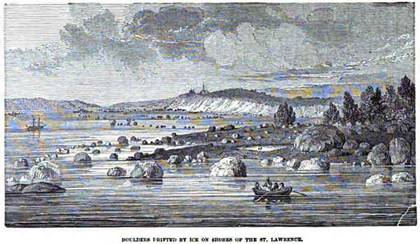
“Boulders drifted by ice on shores of the St. Lawrence” (Lyell, 1833)
Boulder rampart along the Gulf of St Lawrence,
Quebec.
http://gsc.nrcan.gc.ca/landscapes/details_e.php?photoID=690
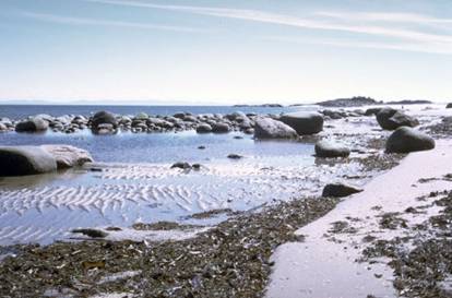
“A striking
contrast of littoral features is revealed in this close-up photo of the shore
along the Gulf of St. Lawrence. Large boulders, ripple marks, and tidal wrack
are seen along the shore. The boulder field shows a 'batture', or boulder
rampart, that developed along the coast. These features are thought to have
formed where debris-laden sea ice drifted onto gently shelving shorelines at
high tide; at low tide, the ice pans carrying the boulders were grounded and
eventually stranded. During subsequent tides, the abandoned boulders acted as
obstacles to anchor more ice pans, and so, over many years, a rampart was built
. . . Another explanation for these features suggests that they may be
wave-washed remnants of old glacial moraines. Perhaps something of both
processes may apply to the origin of this boulder rampart.” (Geological Survey
of Canada, 2009). [It is not clear where or how the "ice pans" would pick up
boulders of this size.]
Lyell was particularly critical of theories such as that advanced by James Hall, which invoked great catastrophes such as tsunamis sweeping across the land: “we cannot be too much on our guard against assuming violent catastrophes where the effects may have been brought about tranquilly, and even with extreme slowness.” Here, Lyell was being true to the philosophy that “actual causes” [present processes] must be employed as much as possible.
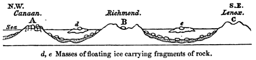
Diagram of erratics being “drifted” from a later text by Lyell (1855, p.92).
“After a repetition of these operations [ice-floes entraining and drifting blocks and other debris before melting] for thousands of years, the uneven bed of the ocean far to the south may be strewed over with drift fragments which have either stranded on shoals or have dropped down from melting bergs. Suppose the floor of the ocean where they alight to be on the rise as gradually as the bottom of the Baltic in our own times. The change may be so insensible that [ships'] pilots may suspect, and yet scarcely dare to insist upon the fact till its reality is confirmed by the experience of centuries. At length a submarine ridge, covered with the travelled fragments, emerges, and first constitutes an island, which at length becomes connected with the main land,—in time, perhaps, the site of a university like Upsala [see "Uppsala" entry for A. de Brongniart]. Here the question is agitated whether the land is stationary, or continually rising beneath their feet. Perchance they decide that it is motionless, and yet it continues to move upwards, "E pur si muove" ["And yet it moves!"], till by a growth as imperceptible as that of the forest tree, what was once a submarine reef becomes the summit of an inland mountain. Here the geologist admires the position, number, and bulk of the transported fragments; identifies them with the parent mountains, a thousand miles distant to the north; and in speculating on the causes of the phaenomena, imagines mighty deluges and tremendous waves raised by the shock of a comet, or the sudden starting up of a chain like the Andes out of the sea, by which huge rocks were scattered over hill and dale as readily as shingle is cast up by the breakers on a sea beach.”
Lyell here also reported that he was now certain that the crust was rising in Sweden, at a faster rate in the north than the south. Land slowly rising and sinking in one region or another as a result of interior forces provided a mechanism for transgressions and regressions of the sea that his explanation required (that it had happened seemed clear enough from the rock record -- see Cuvier and the Introduction). Darwin had also provided substantial evidence of this from his South American travels on the Beagle expedition, where he studied marine terraces and viewed the elevation of and caused by a recent, 1822, earthquake in Chile.
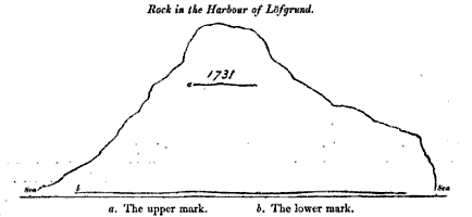
Proof of relatively recent decrease in
sea-level in central Sweden, at Lofgrund:
the upper mark on the rock is 7.5 ft above the present water level of the Baltic
(Lyell 1835, p.19)
Regarding Alpine erratics, Lyell ventured a different, and familiar, explanation: “a combination of local causes might have contributed to their transfer; for repeated shocks of earthquakes may have thrown down rocky fragments upon glaciers, causing at the same time avalanches of snow and ice, by which narrow gorges would be choked up and deep Alpine valleys, such as Chamouni, converted into lakes. In these lakes, portions of the fissured glaciers, with huge incumbent or included rocks might float off, and on the escape of the lake, after the melting of the temporary barrier of snow, they might be swept down into the lower country.”
Lyell studied the “mud-cliffs” of coastal Norfolk in 1829 and again in 1839. Lyell referred to a component of the “mud-cliffs” as “stratified and unstratified drift” – “called by some diluvium.” This drift is similar, he says, to the “boulder formation” (till) he has seen in Denmark and Sweden and which is common “in all countries surrounding the Baltic as well as in northern Russia.” It contains erratics of various sizes. “It may be said to extend uninterruptedly from Sweden through the Danish islands . . . to the borders of Holland, and then to appear again with the same characters in Norfolk and Suffolk.”
“The entire want of a stratified arrangement in the till, whether in Scandinavia, Scotland, or Norfolk, implies some peculiarity in its mode of origin . . . I have seen no kind of deposit now in progress precisely similar in character to the till, except one, namely, the terminal moraines of glaciers. These, as Charpentier has justly remarked, are entirely devoid of stratification, because the accumulation has taken place without the influence of any currents of water by which the materials would be sorted and arranged according to their relative weight and size.”
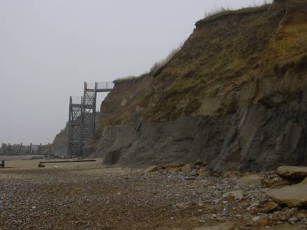
Happisburgh Till (dark, at base) overlain by glacial lake and
meltwater sands and loess (wind-blown silt)
http://www.qpg.geog.cam.ac.uk/events/northnorfolk/NEnorfolk_stop1.html
But, having made this connection, Lyell favored of a different conjecture he had discussed in 1836:
“There can be no doubt that similar accumulations must take place in those parts of every sea, where drift ice, into which mud, sand, and blocks have been frozen, melts in still water, and allows the denser matter to fall tranquilly to the bottom. The occasional intercalation of a layer of stratified matter in the till, or the superposition or juxtaposition of the same, may be explained by the existence or non-existence of currents, during the melting of the ice, whether successively in the same place or simultaneously in different places.”
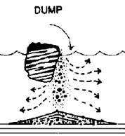
“Ice berg dump till: The structures are consistent . . . with the breakup and overturning of dirt-laden, floating icebergs and the release of large quantities of debris to the bed” (Thomas and Connell, 1985, p.244, 247).
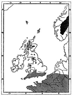
A map from a later publication (1863) shows the southern limit of the region of submergence to which Lyell alluded in 1840 -- the “boulder clay” is to be found in the white (submerged) region and the striped region was not submerged at this time. The darker areas are mountains.
 However,
perhaps the strongest case for the "drift" origin of erratics and drift itself
was at this time made by Roderick Impey Murchison (1792-1871) as part of
his masterly work on “The Silurian System.”
However,
perhaps the strongest case for the "drift" origin of erratics and drift itself
was at this time made by Roderick Impey Murchison (1792-1871) as part of
his masterly work on “The Silurian System.”
His synthesis of the geologic evidence and of the processes involved made the drift theory a difficult theory for others to overcome, and Murchison, along with Lyell and Darwin, never abandoned it.
Murchison used the term drift, as Lyell did: to denote the “superficial detritus” that was the product of regional submergence of the land. He avoided the older term “diluvium” because of what he viewed as its original association with “the [universal] Deluge of Holy Writ” (p.509).
Murchison noted that the drift commonly contained marine shells and so must have been deposited under marine waters. Shells were reportedly found even at altitudes of up to 1750 feet, on Moel Tryfan in Wales (for example, by Joshua Trimmer, in 1834 – something that Murchison went to great pains to substantiate). The fact that these were existing species indicated that the submergence was comparatively recent, according to Murchison. However, some of the shells were reported to be of higher latitude species. Murchison argued that the existence of shells, making the drift “submarine,” precluded a glacial origin, such as was proposed by Esmark (p. 538).
“Northern drift” (as opposed to local drift) also contained erratic “granite bowlders,” indicating that it was “foreign or transported from a distance.”
Murchison, like de Charpentier, reasoned that both the drift and the boulders could not be deposited by a diluvial current because a current, should one be shown strong enough to actually transport the boulders, would have carried off the gravelly and finer drift.
Instead, Murchison argued that the boulders were deposited from melting ice floes (ice bergs) “upon a submarine surface of gravel, sand, and shells” (p.539).
Could ice floes be a viable hypothesis? Present knowledge of ice in the Atlantic suggested that it might be insufficient (p.539), even allowing for colder years on record.
And further against this, the prevailing opinion among geologists was that "evidence went rather to prove the prevalence of a former period of higher temperature. No one, in short, had the means of accounting for the existence of ice in such latitudes . . . Doubtless, if the phenomena had been rare and confined to one part of Europe, a partial deviation from the ordinary course of nature might explain it ; but how are we to reconcile the position of blocks which had been transported from Savoy to the Jura, or from Scandinavia to the plains of Prussia, with such a method of explanation ? Notwithstanding the attempts to apply the iceberg theory generally in aid of the transport of submarine blocks (seeing that in northern latitudes it was a Vera causa), still geologists were wholly unprovided with data to reconcile the former action of ice, in latitudes where it does not now occur, with former condition of Europe favourable to tropical productions: and this argument was vigorously pressed home by the opponents of the theory" (p.540-542).
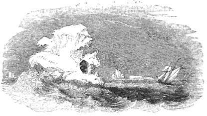
"Rock seen on ice-berg in 61° South Latitude"
Here Murchison made use of soon-to-be published observations by Darwin ("Narrative") concerning ice-berg formation in the southern hemisphere. While this might appear not to apply to the northern hemisphere at first sight, according to Murchison the fact that the seas would be of greater extent at the time of the drift deposition would change the climate, allowing for greater ice-berg production even during a time of warmer temperatures as was the case in the southern hemisphere on the coasts of South America: Darwin "fairly establishes this proposition: - that an equable climate, probably a direct consequence of a large proportional area of water (a probable condition in the geological case under review) is at the same time favourable to the presence of tropical productions, and to a low limit of perpetual snow, and therefore to the descent of glaciers into the sea in latitudes as low as 46' 40'. (pp.283-285) Judging from these examples, he infers, that the dispersion of floating masses of ice, which included fragments of rocks, descending from the mountain chains of central Europe, where islands alone formerly prevailed (the case above supposed), might absolutely have been anticipated to have taken place in the period before the present . . . [Quoting Darwin:]'Even as far north as central Denmark, humming-birds might be seen fluttering about delicate flowers, and parrots feeding amidst the evergreen woods with which the mountains would be clothed down to the water's edge. Nevertheless, the southern part of Scotland (only removed twice as far to the westward) would present an island, 'almost wholly covered with everlasting snow,' and having each bay terminated by ice-cliffs, from which great masses, yearly detached, would sometimes bear with them fragments of rocks. . . . In the Alps themselves (with their altitude reduced by about a half) we should find proofs of recent elevations, and occasionally terrible earthquakes would cause such masses of ice to be precipitated into the sea, that waves tearing all before them would keep together enormous fragments, and pile them up in the corners of the valleys. At other times, icebergs, 'charged with no inconsiderable blocks of granite,' would be floated from the flanks of Mont Blanc, and then stranded on the outlying islands of the Jura. Who then will deny the possibility of these things having actually taken place in Europe during a former period, and under circumstances known to be different from the present, when on merely looking to the other hemisphere we see they are among the daily order of events?' " (Darwin, p.283-285 – see Murchison p542-543). Thus, "temperature is not solely dependent upon latitude."
One last problem concerned the great altitude at which these boulders are found in the Alps. The problem of actually covering the Alps with water is obviated, according to Murchison, but assuming that as the Alps were simply raised from below sea level to a greater height than other areas such as Wales. In discussing (p.545) the raising of the land he reserved the right to believe that it might have been accomplished in the past by forces of greater intensity than are presently evident in the world (and as described by Lyell – above – and Darwin).
Murchison made further sense of the landscape in applying this theory to the origin of certain valleys. He was of the “firm conviction” that existing rivers “would have been perfectly inadequate to excavate the deep hollows [and “transverse gorges” (p.552)] through which they occasionally flow:” “they merely rearrange a few materials distributed by the former action of water, and occasionally make slight changes in their beds” (p.561). However, he argued that the dislocations associated with the “successive upheavings” (p.552) of the land above the sea were responsible for creating gorges, through which the rivers could flow and drain the mountains.
QUESTIONS
REFERENCES
Darwin C. 1837 Observations of proofs of recent elevation of the coast of Chili, made during the survey of His Majesty's ship Beagle, commanded by Capt. Fitzroy, R.N. Proceedings of the Geological Society of London v.2 (48), p.446-449.
http://books.google.com/books?id=dvc4AAAAMAAJ&pg=PA446#v
Darwin C. 1839 Note on a Rock seen on an Iceberg in 61° South Latitude Journal of the Royal Geographic Society, p.528-529 http://books.google.com/books?id=bkMMAAAAIAAJ&pg=PA528#v
Darwin, C. 1839 Narrative of the surveying voyages of his majesty's ships Adventure and Beagle, between the years 1826 and 1836, describing their examination of the southern shores South America, and the Beagle's circumnavigation of the globe. Vol. III. London, Henry Colburn. [See p.289-292] http://www.google.com/books?id=UUWXjlu_JWQC&pg=PA289#v
Lyell, C. 1833 Principles of geology v.3 London John Murray http://www.google.com/books?id=zqkJAAAAIAAJ&pg=PR3
Lyell, C. 1835 On the proofs of the gradual rising of the land in certain parts of Sweden.
Philosophical Transactions of the Royal Society of London 1835 Part 1, p.1-38
http://books.google.com/books?id=oPIAAAAAYAAJ&pg=PA1#v
[BRIEF REPORT: Philosophical Magazine and Journal of Science, v.VI (Jan-Jun 1835) p.297-298 http://books.google.com/books?id=TeevWp5-8iwC&pg=PA297#v]
Lyell, C. 1836 Presidential Address 19 February 1836 Proceedings of the Geological Society of London, Nov 1833 – June 1838 vol. II(44), p.357-390
http://books.google.com/books?id=dvc4AAAAMAAJ&pg=PA357
Lyell, C. 1840 On the Boulder Formation, or drift and associated Freshwater Deposits composing the Mud-cliffs of Eastern Norfolk. The London, Edinburgh and Dublin Philosophical Magazine v.16 (104 - May), p.345-380
http://books.google.com/books?id=J2sqAAAAYAAJ&pg=PA345#v
Lyell, C. 1855 On certain trains of erratic blocks on the Western borders of Massachusetts, United States. Proceedings of the Royal Institution of Great Britain v.2 (1854-1858), p.86-97 http://www.google.com/books?id=tfkAAAAAYAAJ&pg=PA86
Murchison, R.I. 1839 The Silurian System (Part I). London, John Murray.
http://www.uwmc.uwc.edu/geography/Murchison/Murchison-Silurian-System-northern-drift.pdf
Thomas, G.S.P. and Rodger J. Connell , R.J. 1985 Iceberg drop, dump, and grounding structures from Pleistocene glacio-lacustrine sediments, Scotland. Journal of Sedimentary Petrology, v.55(2), p.243-249
Trimmer, T. 1834 Letter from Joshua Trimmer, Esq. to the Rev. Dr. Buckland.V.P. "On the diluvial deposits of Caernarvonshire, between the Snowdon chain of hills and the Menai strait, and on the discovery of marine shells in diluvial sand and gravel on the summit of Moel Tryfane, near Caernarvon, 1000ft above the level of the sea." Proceedings of the Geological Society of London v.1 p.331-332 http://books.google.com/books?id=PDPPAAAAMAAJ&pg=PA331#v
Vetch, [Captain] 1841 Icebergs and changes or geological opinions. The Edinburgh New Philosophical Journal v.31 (April-Oct), p.56-60 http://books.google.com/books?id=21sEAAAAYAAJ&pg=PA56#v