EPISODE:
PETRIDELAUNIAN FLOOD
"The geologist cannot proceed in the way pursued in other sciences; he can only bring forward the results of what has been; but what the cause is he may guess, without coming to other or greater certainty than that which is gained by increased probabilities for the hypothesis."
A student of the renowned chemist J.J. Berzelius and better-known himself as the chemist who re-discovered the element Vanadium, Nils Gabriel Sefstrom (1787-1845) extended Alexandre Brongniart's work in southern Sweden through extensive, detailed mapping of striations and grooves ("furrows") often found in conjunction with roche moutonnees. However, Sefstrom was less circumspect than Brongniart about causes: as he interpreted it, his map showed flood waters fanning out across southern Sweden and heading out across what is today the Baltic.
He attributed the furrowing commonly found on exposed bedrock to "some common geological occurrence, of which these furrows may be the yet remaining marks." He termed the event the "Boulder-flood" (Rullstensflod) or, in Greek, the "Petridelaunian-flood" (Gr. petri: little stones). The northern faces of roche moutonnees were smoothed down by the "Boulder-flood" while southern, lee faces were protected from the "raging flood." He argued, on the basis of furrow preservation, that this event occurred in "a remote age."
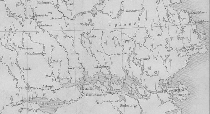
Detail of Sefstrom's
(1836) map of "furrows" on bedrock, Stockholm region.
http://www.uwmc.uwc.edu/geography/Sefstrom/sefstrom-map.pdf
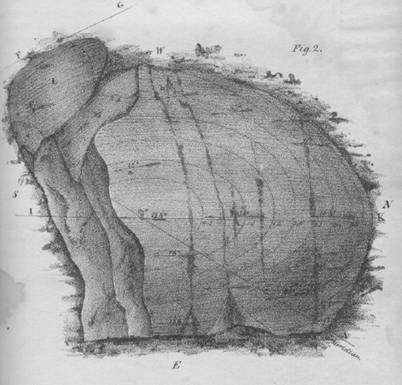
Plan view of a roche mountonnnee in the Fa(h)lun area with
a characteristically smooth northern face and a rough southern (lee) side.
Contours are 0.5ft; north is to the right; arrows on the surface mark the
location and direction of grooves ("furrows") on the surface of the feature (Sefstrom
1836).
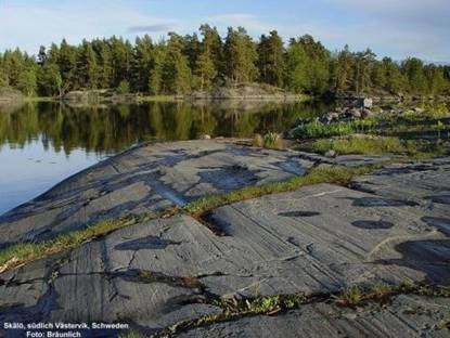
Grooves and striations on bedrock,
Skalo Island, Västervik (SE Sweden).
http://www.kristallin.de/striae/striae_eng.htm
The stones then came to "lie collected in heaps on the extensive hills which we call asar" (eskers). While Brongniart mapped these ridges as continuous systems, Sefstrom took issue with this interpretation: he described them as "sandbanks" that are "seldom found of such great extent as shown on maps; they are composed of several small ridges, which appear to have no other connexion between them." He believed that these ridges often extend from the lee of bedrock knobs and noted that they "have mostly the same direction as the furrows in the same tract."
Sefstrom clearly distinguished between his Boulder-flood of small stones, which scoured the bedrock, and the larger "Earth-stones" (i.e. erratics) "which appear to have been conveyed to their present situations by an agency quite different." Sefstrom did not address the phenomenon of erratics any further in his work.
Sefstrom reasoned that the flood had great depth (1500ft) based on the altitude of features, and was of prolonged violence as witnessed, for example, by giant potholes ("petridelaunian giant-cauldrons").
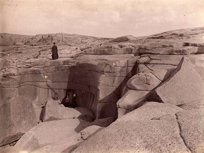
Giant potholes at Stora Testholmen west of Gåsö
in Bohuslän
(north of Goteborg, SW Sweden): note children in pothole.
http://www.kms.raa.se/cocoon/bild/show-image.html?id=16000300029245
Sefstrom wondered if the flood had come down from the mountains of Sweden or from parts further north; he thought the answer would be forthcoming once these areas, as well as North America and Russia, had been mapped in more detail. As to immediate cause he offered two suggestions: either it was a flood, or Earth's axis had shifted and caused the rocks to move across the land. Regarding ultimate cause: "this force will probably for ever be concealed from our researches. This knowledge belongs to Him who shaped the world." He was certain that it did have the purpose of preparing the land for sustaining life.
In an addendum he speculated that the flood had been global and had driven "elephants" north into northern Siberia.
Finally, Sefstrom offered his view on geology: "The geologist cannot proceed in the way pursued in other sciences; he can only bring forward the results of what has been; but what the cause is he may guess, without coming to other or greater certainty than that which is gained by increased probabilities for the hypothesis . . . the opinions of those who have made the next approach to the geological cause, have never the confirmation of certainty. I therefore foresee that the phaenomenon which I have described may possibly by many be ascribed to other causes than those which according to my own views appear most probable for explaining the origin of the furrows and boulders."
QUESTIONS:
1. Sefstrom's detailed observations and his synthesis of data are impressive. Noting also his views on geology, comment on how his ideas support Stephen Jay Gould's contention that:
2. Contrast Sefstrom's approach with that of Alexandre Brongniart to much the same data in Sweden
REFERENCES:
Sefstrom, N.G. 1836 [pub.1838] Undersökning af de räfflor, hvaraf Skandinaviens berg äro med bestämd riktning fårade, samt om deras sannolika uppkomst. Kongliga Vetenskaps Academiens handlingar, for the year 1836 p.141-227 [An investigation of the furrows which traverse the Scandinavian Mountains in certain directions, together with the probable cause of their origin.] http://books.google.com/books?id=Q7g4AAAAMAAJ&pg=RA1-PA41
SUMMARY: 1836 Ueber die spuren einer sehr grossen urwlelticher Fluth. Annalen der Physik und Chemie v.38 p.614-618 http://books.google.com/books?id=u1QrAAAAcAAJ&pg=PA614
FULL ENGLISH TRANSLATION: Sefstrom (Nils Gabriel). An investigation of the furrows which traverse the Scandinavian mountains in certain directions, together with the probable cause of their origin. S. H. Thomas (trans.) p.81-144, 382 (map) in R. Taylor (ed.) 1843 Scientific memoirs v.3 part 9 (R & J. E.Taylor, London) http://books.google.com/books?id=qsY-AAAAYAAJ&pg=PA82#v [missing first page and map]
FULL TEXT PLUS MAP: http://www.uwmc.uwc.edu/geography/Sefstrom/sefstrom.pdf
ENGLISH SUMMARY: Anon, 1837 On the traces of a vast ancient flood (from Poggendorff's Annalen, 1836) The Edinburgh New Philosophical Journal v.XXIII (April-Oct, 1837) p.69-73
http://books.google.com/books?id=DhgXAAAAYAAJ&pg=PA69#v
Sefstrom, N.G., 1843 (1836) Later observations, made partly in Sweden, partly in other countries, communicated in letters to the Royal Academy of Sciences. S. H. Thomas (trans.) p.81-144, 382 (map) in R. Taylor (ed.) 1843 Scientific memoirs v.3 part 9 (R & J. E.Taylor, London) http://books.google.com/books?id=qsY-AAAAYAAJ&pg=PA82#v
p.128-144
Other works:
Sefstrom, N.G. 1838 Untersuchung über die auf den Felsen Skandinaviens in bestimmter Richtung vorhandenen Furchen und deren wahrscheinliche Entstehung. Annalen der Physik und Chemie v.43, p.533-567
http://books.google.com/books?id=8RYAAAAAMAAJ&pg=PA533#v
Sefstrom, N.G. 1838 Tillägg till föregående Afhandling. Sednare observationer, anställde dels i Sverige dels i andra länder, meddelade i bref till Rongl. Vetenskaps-Academien. Kongliga Vetenskaps Academiens Handligar, for ar 1836, p.228-255
http://books.google.com/books?id=Q7g4AAAAMAAJ&pg=RA1-PA228#v