|
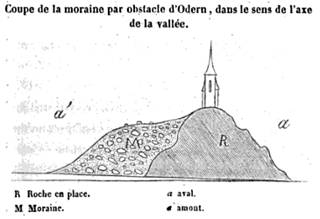
Crag and tail – glacial deposition in the lee of a bedrock obstacle – contrast Hall's interpretation of Edinburgh crag and tail. (Collomb 1847 p.55) |
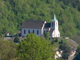
The church at Oderen
|
EPISODE:
VOSGES GLACIATION, 1839
“The strongest consideration indicative of the origin of all these remains, is derived from considering them collectively . . .”
|
Crag and tail – glacial deposition in the lee of a bedrock obstacle – contrast Hall's interpretation of Edinburgh crag and tail. (Collomb 1847 p.55) |
The church at Oderen
|
Both Agassiz and Studer separated glaciation from Charpentier's theory involving the elevation of mountains, and were thus potentially able to include Alpine (Swiss-Italian) and northern European phenomena under a common explanatory canopy.
The first coherent, often overlooked application of “Alpine” ideas to a region not currently occupied by glaciers was completed in 1839 by M. [R?] Renoir who read a paper to the Societie Geologique in Paris in which he laid out evidence of glaciation in the Vosges Mountains of southeastern France.
Significantly, it was accepted that these mountains had not undergone any recent change in elevation, and so Charpentier’s special mechanism for initiating glaciation did not apply. However, Renoir’s mapping of various phenomena suggested that Vosges glaciation was regional and not connected to that of the Alps or to any massive sheets that covered the continent, as Agassiz had suggested. While Renoir’s work was thus the first to apply the glacial model to an area that presently did not support perennial ice it was, however, overshadowed by Agassiz’s similar work in Scotland the next year.
Regarding erratics in the Vosges, Renoir admitted at the outset that “I was accustomed to regard these blocks as having been transported by some great currents; this was the theory most generally received.” However, field work in Alps had lead him to see the evidence differently.
His paper is a model of analogical reasoning and logic as he compared striations, erratics, moraines, and “diluvium” in the Vosges to Alpine examples and then to ideas concerning a deluge. “The strongest consideration indicative of the origin of all these remains, is derived from considering them collectively . . . then, as appears to me, the existence of ancient glaciers on the Vosges Mountains is established.” One important contribution is his inclusion of glacial meltwater as an agent capable of transporting considerable quantities of material in all directions from higher altitudes as glaciers recede – the pattern of deposition he found was difficult to explain by a universal deluge:
“. . . difficulties disappear, and every thing admits of a natural explanation, if we place on the heights (ballons) of Giromagny and Servance, and on the neighbouring elevations, glaciers, which, by their continual movement, would transport, without effort, all the fragments of rocks detached from the summits, and the melting of which would furnish, for a long period, torrents and powerful rivers, conveying to a distance from both sides of the ridge of the chain all the substances which we now call ancient alluvium.”
And: “Now, the torrents of our glaciers sometimes carry along with them . . . such considerable quantities of sand, coarse gravel, and even pebbles, that the country at a distance is covered with them; may we not, then, be permitted to ascribe to the great currents which proceeded from the ancient masses those great mixtures of sand and rolled pebbles which still encumber our lower valleys, and which may be traced without interruption to the height of existing glaciers, or the places which have borne ancient ones, without having recourse to the hypothesis of a deluge, the effects of which would be different from what we now witness[?].”
Edouard Collomb later published a detailed and lavishly illustrated volume on Vosges glaciation.
QUESTIONS
REFERENCES
Agassiz, L. 1840 Etudes sur les glaciers (Agassiz, Jent & Glassmann, Neuchatel) http://books.google.com/books?id=fTMAAAAAQAAJ
TRANSLATION: Carozzi, A.V. (trans) 1967 Studies on glaciers preceded by the Discourse of Neuchatel by Louis Agassiz (Hafner Publishing Company, New York and London)
Collomb, E. 1847 Preuves de l'existence d'anciens glaciers dans les vallées des Vosges. Paris, Victor Masson http://books.google.com/books?id=8usTAAAAQAAJ
Renoir, M. [R?] 1840 On the glaciers which anciently covered the southern side of the mountain-chain of the Vosges The Edinburgh New Philosophical Journal v.XXIX p.280-294 http://books.google.com/books?id=LBkXAAAAYAAJ&pg=PA280
ORIGINAL FRENCH (1839): Note sur les glaciers qui ont recouvert anciennement la partie meridionale de la chaine des Vosges Bulletin de la Societie Geologique de France v.11 (1839-1840) p.53-66 http://books.google.com/books?id=BHq7AAAAIAAJ&pg=PA53
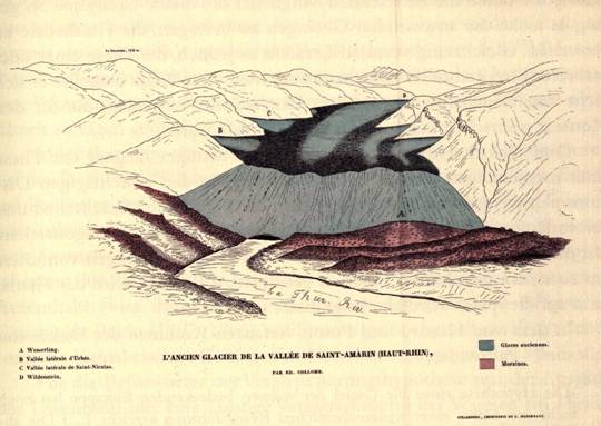
The glacier of the Thur valley (blue-grey), with three terminal moraine ridges (red) at Wesserling
(Collomb, 1847)
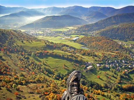
The moraine ridge at Oderen, in the Thur valley to the north of Wesserling
http://mw2.google.com/mw-panoramio/photos/medium/17350527.jpg
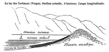
Lac des Corbeaux (seen in the GoogleEarth placemark) is a moraine-dammed cirque lake
(Collomb, 1847, p.154)
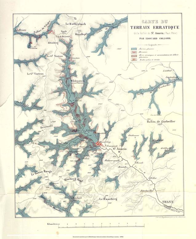
Collomb’s (1847)
remarkable map
of Vosges glaciers (blue) with erratics (red dots), moraines (dark red bands),
and
polished rocks and striations (light red). Lac des Corbeaux is
in the northwest corner of the Colline de Vologne.
Use ctrl +/- to zoom in to the map details.